

Elms-Old Rexdale
Rexdale Plaza
2267 Islington Avenue
Rex Heslop established Rex Heslop Homes Ltd. around 1950. His first development included 400 homes in Alderwood in south Etobicoke. As Heslop continued to develop homes and plan communities, he simultaneously built industrial properties in the area to encourage tax revenues from businesses and jobs for the growing number of residents. Taxes went to the establishment of roads, schools and other services. Heslop continued to develop many suburban areas and subdivisions in Etobicoke, including Kipling Heights, West Humber Estates and The Elms. In 1952, the first official Rexdale post office opened, and in 1956, Heslop built Rexdale Plaza on the east side of Islington Avenue. It was the fourth retail plaza built in Toronto, constructed as an outdoor shopping centre for the area. The surrounding neighbourhood was developed as a subdivision, also designed by Rex Heslop, and named Rexdale. The shops in the mall were enclosed in 1972, and by 2003 the old mall was demolished and redeveloped as an outdoor mall, harkening back to its original design. Today, the mall houses a collection of great local businesses.
The Elms Park
25 Auburndale Court
This park follows Berry Creek - a tributary of the Humber River - as it flows through the neighbourhood. The Elms name comes from a former golf course that used to occupy much of the land here north of Hadrian Drive between Islington Avenue and Albion Road. The park features a T-Rex themed playground that was constructed over three days in 2014 and filmed as part of the TVO show 'Giver'.
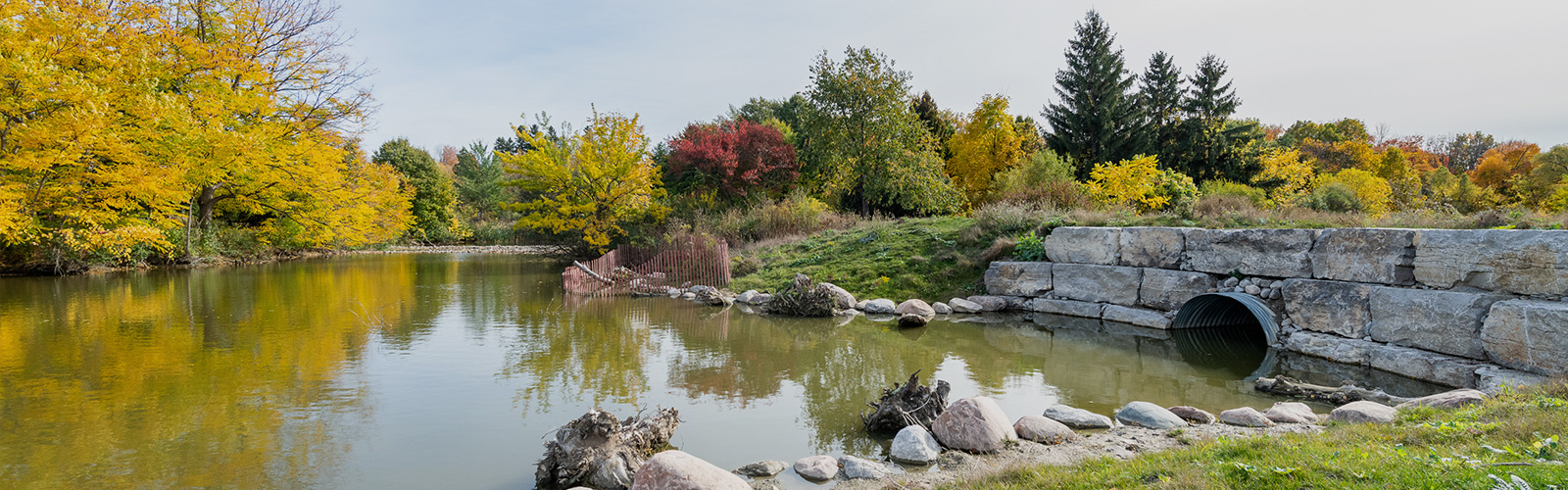
West Humber Parkland
451 Albion Road
West Humber Parkland is located in the east end of Rexdale near the Highway 401 and 400 interchange. It is the gateway to the extensive Humber Recreational Trail system travelling both east and west along the Humber River and its tributaries. West Humber Parkland has two playgrounds, five soccer fields, and open space for picnics. Its trails are an excellent place to view wildlife and spot waterfowl.
Summerlea Park
2 Arcot Boulevard
A 23-hectare park near Albion Road and Islington Avenue follows along the banks of the Humber River West Branch as it joins the Humber River. In addition to the many trails and naturalized river valley, the park features a ball diamond, three multipurpose fields, a cricket pitch, two basketball courts, two tennis courts, a wading pool and a children's playground.
Humber River Recreational Trail
Along the Humber River throughout the area
The paved 19-kilometre Humber River Recreational Trail follows the path of the Humber River and connects a number of parks along the water and is one length of the Pan Am Path. It includes forested areas and recreational spaces. The trail is an ideal location for wildlife spotting.
Birch, Red Willow, Ash, Jack Pine and Maple: The Anishinaabe Lodge
Along the Humber River Recreational Trail
There are many plants and medicines within the Humber River area, and many of them can be found throughout Toronto and Ontario. While there are medicines shared by the different First Nations, medicines, like everything else, have different teachings and stories associated with them. Traditional medicines can be found throughout the region of the Humber River, and the diverse medicines reflect the varying groups of people who have lived within this area. The lodge is a central space for Anishinaabe ceremonies and teachings. A sweat lodge is a dome-shaped structure. When people talk about the lodge they talk about entering the womb of Mother Earth. It is a sacred place. There is a specific way to construct and look after a lodge, and conduct ceremony within this space. Only certain individuals are given this responsibility. There is a Sweat Lodge Ceremony that is done in this space. A Sweat is sometimes carried out as its own ceremony, but other ceremonies like Fasting are occasionally begun or finished with a Sweat Lodge Ceremony. Many of the medicines used in the construction of a lodge can be found in the Humber region. A lodge is made of a specific number of red willow, ash, birch, maple or jack pine saplings. Some teachings refer to the frame as the ribs of Mother Earth. Tobacco is placed at the base of the hole that each pole is set into.
The Carrying Place Trail: Pine Point Park
4 Conan Road (within Pine Point Park)
Pine Point Park is nestled along the bank of Kabechenong, also known as the Humber River. For thousands of years, Kabechenong has been a place of trade, travel, and commerce. Situated within a larger network of rivers, streams, and creeks, this river travels through the Niagara Escarpment and the Oak Ridges Moraine. The mouth of Kabechenong opens into Lake Ontario. Kabechenong is part of the Carrying Place Trail, an Indigenous trail system used most recently by the Anishinaabe, the Haudenosaunee, and the Wendat nations. This trail is made of a series of portage and foot paths that acted as a highway system between Lake Ontario and Lake Simcoe, connecting Lake Ontario to the Upper Great Lakes. There are several known Indigenous villages and campsites along Kabechenong, including the Haudenosaunee village of Teiaiagon near the neighbourhood now referred to as Baby Point. The significance of Kabechenong as part of an existing Indigenous trade route attracted French and later British settlement. In September 1999, Kabechenong was designated as a Canadian Heritage River. It is the only river in the GTA with this designation and one of forty across Canada.
White Pine and the Haudenosaunee Confederacy
4 Conan Road (within Pine Point Park)
The Humber River area is home to a wide variety of plant life including the white pine tree. The white pine is a tall, coniferous tree, whose needles grow in bunches of five. Rich in vitamin C, this tree can be used to make a medicinal tea. The sap can be used to protect and heal wounds as well as to waterproof baskets and canoes. The white pine is of particular significance to members of the Haudenosaunee Confederacy, also known as the People of the Longhouse. The Tuscarora, Oneida, Mohawk, Seneca, Cayuga and the Onondaga are the nations that make up this confederacy. It was founded by the prophet known as the Peacemaker with the help of his friend Aionwatha. For generations, all but the Tuscarora had been at war with each other. The Peacemaker had a vision of unity and friendship for these warring nations. He convinced their Chiefs to meet with him under a giant white pine tree to discuss his vision for peace. He convinced them to bury their weapons beneath the tree and join together in friendship. The white pine continues to be an important symbol of unity for the Haudenosaunee people.
'Born This Way' Mural
On the Highway 401 underpass along the Humber River Recreational Trail in Pine Point Park
This mural was designed by members of the Essencia Art Collective in collaboration with the Centre for Spanish Speaking Peoples. It was painted as part of the Pan Am Path's Art Relay, a 14-week program that animated the pathway with arts projects across the city. As part of the project, organizers led anti-homophobia workshops in the local community and painted the mural as a celebration of the LGBTQ2S+ community.
Pine Point Park
4 Conan Road
A sprawling 39-hectare park near Highway 401 and Islington Avenue that connects with the Humber River Recreational Trail. The park features six lit tennis courts, a mini soccer field, a multipurpose sports field and a children's playground. The park's wooded trails follow the banks of the Humber River and extend out to several surrounding neighbourhood streets. Additional amenities located in the park are the Pine Point Outdoor Pool and the Pine Point Arena. The park was originally opened in 1957 and was the first in the Rexdale area.
Pine Point Park Banquet Hall
15 Grierson Road
Built in 1936, this idyllic Banquet Hall overlooks the Humber River Valley. Built in Tudor Revival style, the hall uses Humber River stone on the lower level. In 1925, the land was purchased for a new golf course, and in 1932, it was sold to Bert and Frank Deakin, who named it Pine Point Golf and Country Club. As Toronto expanded, they sold parts of the land and the clubhouse (Banquet Hall) to the Township of Etobicoke in 1950 for the building of Highway 401, which ran through the middle of the golf course. The Township of Etobicoke used the land to create Pine Point Park for use by the public. The former clubhouse is City-owned, but is operated by the Thistletown Lions Club.
Explore Elms-Old Rexdale
Now is the time for residents to experience all that tourists have been raving about for years. Discover shops, stops, places and spaces on city main streets. Stay curious, Toronto.
We want to hear from you! Click here to complete a short survey
We hope that you enjoyed exploring this Toronto neighbourhood and found many other points of interest along the way. While StrollTO highlights some of the 'hidden gems' in the neighbourhood, there may be others that could be included in a future edition. Would you like to share a point of interest that you discovered in the neighbourhood? Email us at [email protected].
Neighbourhood Stroll
This suburban, residential neighbourhood is dominated by the vast parklands along the sides of the Humber River, along with quiet residential streets and shopping plazas scattered throughout. It has a rich Indigenous past along the shores of the Humber River, and Islington Avenue and Albion Road both feature plenty of great local businesses.
- Rexdale Plaza
2267 Islington Avenue
Rex Heslop established Rex Heslop Homes Ltd. around 1950. His first development included 400 homes in Alderwood in south Etobicoke. As Heslop continued to develop homes and plan communities, he simultaneously built industrial properties in the area to encourage tax revenues from businesses and jobs for the growing number of residents. Taxes went to the establishment of roads, schools and other services. Heslop continued to develop many suburban areas and subdivisions in Etobicoke, including Kipling Heights, West Humber Estates and The Elms. In 1952, the first official Rexdale post office opened, and in 1956, Heslop built Rexdale Plaza on the east side of Islington Avenue. It was the fourth retail plaza built in Toronto, constructed as an outdoor shopping centre for the area. The surrounding neighbourhood was developed as a subdivision, also designed by Rex Heslop, and named Rexdale. The shops in the mall were enclosed in 1972, and by 2003 the old mall was demolished and redeveloped as an outdoor mall, harkening back to its original design. Today, the mall houses a collection of great local businesses.
- The Elms Park
25 Auburndale Court
This park follows Berry Creek - a tributary of the Humber River - as it flows through the neighbourhood. The Elms name comes from a former golf course that used to occupy much of the land here north of Hadrian Drive between Islington Avenue and Albion Road. The park features a T-Rex themed playground that was constructed over three days in 2014 and filmed as part of the TVO show 'Giver'.
- West Humber Parkland
451 Albion Road
West Humber Parkland is located in the east end of Rexdale near the Highway 401 and 400 interchange. It is the gateway to the extensive Humber Recreational Trail system travelling both east and west along the Humber River and its tributaries. West Humber Parkland has two playgrounds, five soccer fields, and open space for picnics. Its trails are an excellent place to view wildlife and spot waterfowl.
- Summerlea Park
2 Arcot Boulevard
A 23-hectare park near Albion Road and Islington Avenue follows along the banks of the Humber River West Branch as it joins the Humber River. In addition to the many trails and naturalized river valley, the park features a ball diamond, three multipurpose fields, a cricket pitch, two basketball courts, two tennis courts, a wading pool and a children's playground.
- Humber River Recreational Trail
Along the Humber River throughout the area
The paved 19-kilometre Humber River Recreational Trail follows the path of the Humber River and connects a number of parks along the water and is one length of the Pan Am Path. It includes forested areas and recreational spaces. The trail is an ideal location for wildlife spotting.
- Birch, Red Willow, Ash, Jack Pine and Maple: The Anishinaabe Lodge
Along the Humber River Recreational Trail
There are many plants and medicines within the Humber River area, and many of them can be found throughout Toronto and Ontario. While there are medicines shared by the different First Nations, medicines, like everything else, have different teachings and stories associated with them. Traditional medicines can be found throughout the region of the Humber River, and the diverse medicines reflect the varying groups of people who have lived within this area. The lodge is a central space for Anishinaabe ceremonies and teachings. A sweat lodge is a dome-shaped structure. When people talk about the lodge they talk about entering the womb of Mother Earth. It is a sacred place. There is a specific way to construct and look after a lodge, and conduct ceremony within this space. Only certain individuals are given this responsibility. There is a Sweat Lodge Ceremony that is done in this space. A Sweat is sometimes carried out as its own ceremony, but other ceremonies like Fasting are occasionally begun or finished with a Sweat Lodge Ceremony. Many of the medicines used in the construction of a lodge can be found in the Humber region. A lodge is made of a specific number of red willow, ash, birch, maple or jack pine saplings. Some teachings refer to the frame as the ribs of Mother Earth. Tobacco is placed at the base of the hole that each pole is set into.
- The Carrying Place Trail: Pine Point Park
4 Conan Road (within Pine Point Park)
Pine Point Park is nestled along the bank of Kabechenong, also known as the Humber River. For thousands of years, Kabechenong has been a place of trade, travel, and commerce. Situated within a larger network of rivers, streams, and creeks, this river travels through the Niagara Escarpment and the Oak Ridges Moraine. The mouth of Kabechenong opens into Lake Ontario. Kabechenong is part of the Carrying Place Trail, an Indigenous trail system used most recently by the Anishinaabe, the Haudenosaunee, and the Wendat nations. This trail is made of a series of portage and foot paths that acted as a highway system between Lake Ontario and Lake Simcoe, connecting Lake Ontario to the Upper Great Lakes. There are several known Indigenous villages and campsites along Kabechenong, including the Haudenosaunee village of Teiaiagon near the neighbourhood now referred to as Baby Point. The significance of Kabechenong as part of an existing Indigenous trade route attracted French and later British settlement. In September 1999, Kabechenong was designated as a Canadian Heritage River. It is the only river in the GTA with this designation and one of forty across Canada.
- White Pine and the Haudenosaunee Confederacy
4 Conan Road (within Pine Point Park)
The Humber River area is home to a wide variety of plant life including the white pine tree. The white pine is a tall, coniferous tree, whose needles grow in bunches of five. Rich in vitamin C, this tree can be used to make a medicinal tea. The sap can be used to protect and heal wounds as well as to waterproof baskets and canoes. The white pine is of particular significance to members of the Haudenosaunee Confederacy, also known as the People of the Longhouse. The Tuscarora, Oneida, Mohawk, Seneca, Cayuga and the Onondaga are the nations that make up this confederacy. It was founded by the prophet known as the Peacemaker with the help of his friend Aionwatha. For generations, all but the Tuscarora had been at war with each other. The Peacemaker had a vision of unity and friendship for these warring nations. He convinced their Chiefs to meet with him under a giant white pine tree to discuss his vision for peace. He convinced them to bury their weapons beneath the tree and join together in friendship. The white pine continues to be an important symbol of unity for the Haudenosaunee people.
- 'Born This Way' Mural
On the Highway 401 underpass along the Humber River Recreational Trail in Pine Point Park
This mural was designed by members of the Essencia Art Collective in collaboration with the Centre for Spanish Speaking Peoples. It was painted as part of the Pan Am Path's Art Relay, a 14-week program that animated the pathway with arts projects across the city. As part of the project, organizers led anti-homophobia workshops in the local community and painted the mural as a celebration of the LGBTQ2S+ community.
- Pine Point Park
4 Conan Road
A sprawling 39-hectare park near Highway 401 and Islington Avenue that connects with the Humber River Recreational Trail. The park features six lit tennis courts, a mini soccer field, a multipurpose sports field and a children's playground. The park's wooded trails follow the banks of the Humber River and extend out to several surrounding neighbourhood streets. Additional amenities located in the park are the Pine Point Outdoor Pool and the Pine Point Arena. The park was originally opened in 1957 and was the first in the Rexdale area.
- Pine Point Park Banquet Hall
15 Grierson Road
Built in 1936, this idyllic Banquet Hall overlooks the Humber River Valley. Built in Tudor Revival style, the hall uses Humber River stone on the lower level. In 1925, the land was purchased for a new golf course, and in 1932, it was sold to Bert and Frank Deakin, who named it Pine Point Golf and Country Club. As Toronto expanded, they sold parts of the land and the clubhouse (Banquet Hall) to the Township of Etobicoke in 1950 for the building of Highway 401, which ran through the middle of the golf course. The Township of Etobicoke used the land to create Pine Point Park for use by the public. The former clubhouse is City-owned, but is operated by the Thistletown Lions Club.
Accessibility information: All points of interest on this stroll are viewable and can be enjoyed from the street, sidewalk, or paved paths within the parks.
The StrollTO itineraries may follow routes that do not receive winter maintenance. Please review winter safety tips and for more information contact 311.
Soundtracks of the City
From global superstars to local favourites and ones to watch, the Soundtracks of the City playlists all feature artists who have called Toronto home. Whether it’s a lyric about the neighborhood, an artist representing a cultural community, or a tie-in to the StrollTO itinerary itself, all the music reflects connections to an individual ward or the City as a whole.
Music was chosen based on an artist’s Spotify presence and each song’s broad appeal, as well as its associations with the cultures, languages and ethnicities that reflect Toronto’s neighborhoods and diverse music scene. Soundtracks of the City combines 425 songs that feature more than 500 different local artists or acts, showcasing songs in 23 different languages.