

Humber Bay Shores
Mimico Waterfront Park
29 Norris Crescent
This park lies on the Lake Ontario Waterfront between Humber Bay Park West and Norris Crescent Parkette. Its features include 1.1km of multi-use waterfront trail, headlands and cobble beaches, a small bay, boardwalks with small pockets of wetland habitat between the boardwalk and shoreline, and terrestrial and aquatic habitat enhancements to support healthy ecosystems. This park was created by Toronto and Region Conservation Authority (TRCA) with funds provided by Waterfront Toronto. It was developed in two phases, the first completed in 2008 and the second in 2012. It provides safe access to the waterfront, improves the ecological functioning of this section of the Lake Ontario shoreline and offers environmental, economic and social benefits to the Mimico community and broader region.
Jim Bravo and Emanuel Ciobanica 'Down the Creek Way' & 'Morning Ice Harvest on the Humber' Mural
2491 Lake Shore Boulevard West (North Side of Building)
Artists Jim Bravo and Emanuel Ciobanica designed and painted both murals to highlight the neighbourhood's proximity to the lake and its historical importance in the community. 'Down the Creek Way' is the colourful mural on the right depicting a nostalgic view of swimmers about to bathe in Mimico Creek in the 1920s. 'Morning Ice Harvest on the Humber' honours those who gathered ice from the Humber River - a necessary commodity in the days before air conditioning and refrigeration.
Aisha Ali Artbox
East Side of Lake Shore Boulevard West at Mimico Avenue
This mural is a homage to all the spectacular wildlife of Toronto as well as a reminder that Toronto is built on and continues to coexist with wetlands.
Alexa Hatanaka and Patrick Thompson 'Fowl Play' Mural
2413 Lake Shore Boulevard West
The visually stimulating and playful underwater scene in this 'Fowl Play' mural was inspired by its lakeshore setting and the bird-friendly, shade-grown, organic coffee shop within the building.
Alexa Hatanaka and Patrick Thompson 'Wave' Mural
Along Fence in Northern Edge of Amos Waites Park (2441 Lake Shore Boulevard West)
In 2012, artists Patrick Thompson and Alexa Hatanaka designed this 7.32-metre-long art installation on a fence adjacent to Amos Waites Park, which was named for a former Mimico mayor. This mural visually interprets the waters that surround the neighbourhood as a continuous wave in a playful and whimsical way, bringing the lake to the street.
'Warehouse 13' Filming Location
2399 Lake Shore Boulevard West
This local business was used as a filming location for the popular American science fiction series 'Warehouse 13' starring Canadian actress Joanna Kelly, and American actor Eddie McClintock. The business stands in as the Elk Ridge Valu Mart in the episode entitled 'Emily Lake' from the third season of the show. The plot of the episode involves the lead characters travelling to Wyoming to investigate the theft of a top secret document. The episode was directed by Millicent Shelton, who is well-known for directing episodes of many famous television shows, as well as a number of famous music videos in the 1990s. Shelton also became the first Black woman nominated for a primetime Emmy for directing for her work on the show '30 Rock'.
Jen Bulthuis Artbox
Southeast Corner of Lake Shore Boulevard West and Superior Avenue
The design is an aquarium of endangered species, emphasizing humans' relationship with animals in the wild and the mystery that these creatures hold.
Humber Bay Park West
2225 Lake Shore Boulevard West
Humber Bay Park West is a narrow park jutting out into the water of Lake Ontario in the City's west end. It's an excellent spot for bird watchers hoping to find interesting waterfowl and shorebirds. Along the shores of Humber Bay West, you'll also spot a wide variety of ducks overwintering in Lake Ontario. Combine your walk through Humber Bay Park West with a loop around Humber Bay Park East for a great day of hiking. A number of parking lots and paved pathways make this an accessible park.
Mimico Creek Bridge
Crosses over Mimico Creek Between Humber Bay Park West and East
Located at the southern end of Mimico Creek, this bridge connects the two Humber Bay parks. Designed by internationally celebrated Spanish architect Santiago Calatrava, the bridge has a one-sided tilted arch that complements the nearby Humber Bay Pedestrian Bridge.
Mimico Creek
225 Humber Bay Park Road West
The name Mimico is an adaptation of the Anishinaabemowin term Omiimiikaa, which means 'place of the wild pigeon'. It describes how the area was once home to many thousands of passenger pigeons. This large population was sustained by an equally large supply of seeds, acorns, and other nuts available within the vast Black Oak savanna just East of Omiimiikaa in the area of the Humber River, High Park, and Roncesvalles. Because the savannas were maintained and expanded by First Nations people through controlled burns, the historic presence of the passenger pigeons here can be linked directly to First Nations gardening practices and land stewardship. The passenger pigeon, in turn, formed a significant part of local First Nations diets and Omiimiikaa was thus an important hunting ground. It is estimated that at the peak of their population there were five billion passenger pigeons across Turtle Island, roughly forty percent of the continent's entire bird population! Passenger pigeons were migratory, but would return to the same nesting places, like Omiimiikaa year after year. In these nesting areas, trees would sometimes have so many nests that their branches would break under the weight. Sadly, passenger pigeons became extinct in a stunningly short period of time. With colonial expansion, so many birds were killed every season that their numbers became fewer every year. Unfortunately, at the time of settlement, they began to be hunted in excess to feed the growing population. The recognition of their endangered state came too late and the efforts to save the species were unsuccessful. The passenger pigeon was officially announced extinct in 1914.
Air India Sundial
Within Humber Bay Park East (Northeast of Main Parking Lot)
The Air India Sundial commemorates the 329 victims of the bombing of Air India Flight 182 on June 23, 1985. The flight was en route to Delhi from Montreal, when it was bombed over the Atlantic Ocean off the southwest coast of Ireland. A memorial was constructed in Ireland in 1986, featuring a sundial as a key component. The Canadian monument was installed in 2007. The sundial reads, 'Time flies, suns rise, and shadows fall, let it pass by, love reigns forever over all'. The monument also includes two walls bearing the names of the victims. The federal government of Canada declared June 23 as the National Day of Remembrance for Victims of Terrorism.
Humber Bay Park East
100 Humber Bay Park Road West
Humber Bay Park East sits on an expansive peninsula that spreads out into Lake Ontario and allows you to take fantastic photographs of the Toronto skyline from its eastern shores. The park has plenty of parking space, for those who may be hauling a big family picnic; two seasonally available drinking fountains and a public washroom. Use the trails to explore the native flora and fauna, the pond and butterfly habitat, and the peninsula's many great beaches and picnic spots!
Humber Bay Butterfly Habitat
100 Humber Bay Park Road West
The Humber Bay Butterfly Habitat (HBBH) is an ecological restoration project that provides a critical habitat for a variety of native butterfly species. Located along the shores of Lake Ontario in Toronto's west end, HBBH incorporates a diversity of native wildflowers, shrubs, trees, grasses, hedges and a variety of physical features known to support butterflies throughout their life cycles. Interpretive features explore the relationship between butterflies and their natural habitat. The goal of the HBBH is to establish a self-sustaining native plant community, which will support a variety of butterfly species while educating park users about the value of urban conservation.
Humber Bay Shores Park
15 Marine Parade Drive
Humber Bay Shores Park is located west of the Humber Bay Bridge and the Humber River, east of the Humber Bay East and West Parks. It is part of a string of parks along the Etobicoke Lakeshore district that connect by the Martin Goodman Trail. Humber Bay Shores is a lovely spot to sit and enjoy the view of Lake Ontario. This park is listed as one of the top 13 spots to see birds in Toronto in the City's Birds of Toronto Biodiversity Series booklet, which is available in libraries across the city.
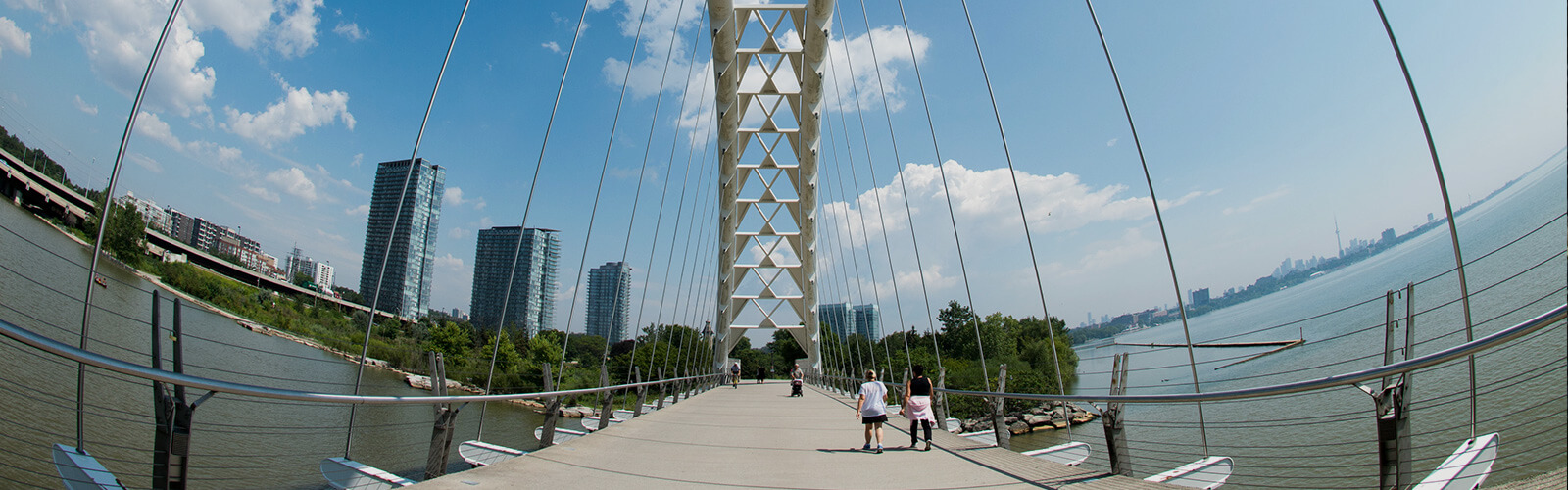
Humber Bay Pedestrian Bridge
Martin Goodman Trail
The Humber River, known to the Anishinaabeg as Kabechenong, has been the site of Indigenous trade, travel, and commerce for thousands of years. The mouth of the river marks the southern end of the Carrying Place Trail, an Indigenous trail system of portage and foot paths that acted as a highway system between Lake Ontario and Lake Simcoe. The significance of Kabechenong as part of an existing Indigenous trade route attracted French and later British settlement. The Humber Bay Pedestrian Bridge, sometimes referred to as the Gateway Bridge, rests above the mouth of the Humber River where it opens into Lake Ontario. It was completed in 1994, is 139 meters long, 6.5 meters wide and cost $4,050,000 to build. The structure of the bridge includes a visual reference to the spiritual beings known to the Anishinaabeg as Thunderbirds. The steel superstructure connecting the two ribs of the tied arch is patterned in an abstract version of the Thunderbird. Turtles, canoes, and salmon are represented beneath the bridge, which act to commemorate the enduring presence of First Nations people in this area, as well as the other beings who have called this land and water home for time immemorial. Renowned Ojibwe artist Ahmoo Angeconeb was the First Nations art consultant for this project. He was a residential school survivor and a member of Lac Seul First Nation who was known for his printmaking and sculptures.
Explore Humber Bay Shores
Now is the time for residents to experience all that tourists have been raving about for years. Discover shops, stops, places and spaces on city main streets. Stay curious, Toronto.
We want to hear from you! Click here to complete a short survey
Don't Miss
Explore FREE Public Art Across the City. Toronto's Year of Public Art 2021-2022 is a year-long celebration of Toronto's exceptional public art collection and the creative community behind it.
We hope that you enjoyed exploring this Toronto neighbourhood and found many other points of interest along the way. While StrollTO highlights some of the 'hidden gems' in the neighbourhood, there may be others that could be included in a future edition. Would you like to share a point of interest that you discovered in the neighbourhood? Email us at [email protected].
Neighbourhood Stroll
Few neighbourhoods in Toronto have undergone as dramatic a transformation as Humber Bay Shores, which in a few short years has gone from a sleepy strip of low-rise motels to one of the most densely populated areas of the city with new condominiums towering over the Lake Ontario shoreline. The area also provides some of the best waterfront parkland in Toronto, which offers spectacular views over the lake and towards the downtown skyline. This stroll features many of these parklands, as well as some beautiful public art. Great local businesses can be found in the Mimico by the Lake BIA.
- Mimico Waterfront Park
29 Norris Crescent
This park lies on the Lake Ontario Waterfront between Humber Bay Park West and Norris Crescent Parkette. Its features include 1.1km of multi-use waterfront trail, headlands and cobble beaches, a small bay, boardwalks with small pockets of wetland habitat between the boardwalk and shoreline, and terrestrial and aquatic habitat enhancements to support healthy ecosystems. This park was created by Toronto and Region Conservation Authority (TRCA) with funds provided by Waterfront Toronto. It was developed in two phases, the first completed in 2008 and the second in 2012. It provides safe access to the waterfront, improves the ecological functioning of this section of the Lake Ontario shoreline and offers environmental, economic and social benefits to the Mimico community and broader region.
- Jim Bravo and Emanuel Ciobanica 'Down the Creek Way' & 'Morning Ice Harvest on the Humber' Mural
2491 Lake Shore Boulevard West (North Side of Building)
Artists Jim Bravo and Emanuel Ciobanica designed and painted both murals to highlight the neighbourhood's proximity to the lake and its historical importance in the community. 'Down the Creek Way' is the colourful mural on the right depicting a nostalgic view of swimmers about to bathe in Mimico Creek in the 1920s. 'Morning Ice Harvest on the Humber' honours those who gathered ice from the Humber River - a necessary commodity in the days before air conditioning and refrigeration.
- Aisha Ali Artbox
East Side of Lake Shore Boulevard West at Mimico Avenue
This mural is a homage to all the spectacular wildlife of Toronto as well as a reminder that Toronto is built on and continues to coexist with wetlands.
- Alexa Hatanaka and Patrick Thompson 'Fowl Play' Mural
2413 Lake Shore Boulevard West
The visually stimulating and playful underwater scene in this 'Fowl Play' mural was inspired by its lakeshore setting and the bird-friendly, shade-grown, organic coffee shop within the building.
- Alexa Hatanaka and Patrick Thompson 'Wave' Mural
Along Fence in Northern Edge of Amos Waites Park (2441 Lake Shore Boulevard West)
In 2012, artists Patrick Thompson and Alexa Hatanaka designed this 7.32-metre-long art installation on a fence adjacent to Amos Waites Park, which was named for a former Mimico mayor. This mural visually interprets the waters that surround the neighbourhood as a continuous wave in a playful and whimsical way, bringing the lake to the street.
- 'Warehouse 13' Filming Location
2399 Lake Shore Boulevard West
This local business was used as a filming location for the popular American science fiction series 'Warehouse 13' starring Canadian actress Joanna Kelly, and American actor Eddie McClintock. The business stands in as the Elk Ridge Valu Mart in the episode entitled 'Emily Lake' from the third season of the show. The plot of the episode involves the lead characters travelling to Wyoming to investigate the theft of a top secret document. The episode was directed by Millicent Shelton, who is well-known for directing episodes of many famous television shows, as well as a number of famous music videos in the 1990s. Shelton also became the first Black woman nominated for a primetime Emmy for directing for her work on the show '30 Rock'.
- Jen Bulthuis Artbox
Southeast Corner of Lake Shore Boulevard West and Superior Avenue
The design is an aquarium of endangered species, emphasizing humans' relationship with animals in the wild and the mystery that these creatures hold.
- Humber Bay Park West
2225 Lake Shore Boulevard West
Humber Bay Park West is a narrow park jutting out into the water of Lake Ontario in the City's west end. It's an excellent spot for bird watchers hoping to find interesting waterfowl and shorebirds. Along the shores of Humber Bay West, you'll also spot a wide variety of ducks overwintering in Lake Ontario. Combine your walk through Humber Bay Park West with a loop around Humber Bay Park East for a great day of hiking. A number of parking lots and paved pathways make this an accessible park.
- Mimico Creek Bridge
Crosses over Mimico Creek Between Humber Bay Park West and East
Located at the southern end of Mimico Creek, this bridge connects the two Humber Bay parks. Designed by internationally celebrated Spanish architect Santiago Calatrava, the bridge has a one-sided tilted arch that complements the nearby Humber Bay Pedestrian Bridge.
- Mimico Creek
225 Humber Bay Park Road West
The name Mimico is an adaptation of the Anishinaabemowin term Omiimiikaa, which means 'place of the wild pigeon'. It describes how the area was once home to many thousands of passenger pigeons. This large population was sustained by an equally large supply of seeds, acorns, and other nuts available within the vast Black Oak savanna just East of Omiimiikaa in the area of the Humber River, High Park, and Roncesvalles. Because the savannas were maintained and expanded by First Nations people through controlled burns, the historic presence of the passenger pigeons here can be linked directly to First Nations gardening practices and land stewardship. The passenger pigeon, in turn, formed a significant part of local First Nations diets and Omiimiikaa was thus an important hunting ground. It is estimated that at the peak of their population there were five billion passenger pigeons across Turtle Island, roughly forty percent of the continent's entire bird population! Passenger pigeons were migratory, but would return to the same nesting places, like Omiimiikaa year after year. In these nesting areas, trees would sometimes have so many nests that their branches would break under the weight. Sadly, passenger pigeons became extinct in a stunningly short period of time. With colonial expansion, so many birds were killed every season that their numbers became fewer every year. Unfortunately, at the time of settlement, they began to be hunted in excess to feed the growing population. The recognition of their endangered state came too late and the efforts to save the species were unsuccessful. The passenger pigeon was officially announced extinct in 1914.
- Air India Sundial
Within Humber Bay Park East (Northeast of Main Parking Lot)
The Air India Sundial commemorates the 329 victims of the bombing of Air India Flight 182 on June 23, 1985. The flight was en route to Delhi from Montreal, when it was bombed over the Atlantic Ocean off the southwest coast of Ireland. A memorial was constructed in Ireland in 1986, featuring a sundial as a key component. The Canadian monument was installed in 2007. The sundial reads, 'Time flies, suns rise, and shadows fall, let it pass by, love reigns forever over all'. The monument also includes two walls bearing the names of the victims. The federal government of Canada declared June 23 as the National Day of Remembrance for Victims of Terrorism.
- Humber Bay Park East
100 Humber Bay Park Road West
Humber Bay Park East sits on an expansive peninsula that spreads out into Lake Ontario and allows you to take fantastic photographs of the Toronto skyline from its eastern shores. The park has plenty of parking space, for those who may be hauling a big family picnic; two seasonally available drinking fountains and a public washroom. Use the trails to explore the native flora and fauna, the pond and butterfly habitat, and the peninsula's many great beaches and picnic spots!
- Humber Bay Butterfly Habitat
100 Humber Bay Park Road West
The Humber Bay Butterfly Habitat (HBBH) is an ecological restoration project that provides a critical habitat for a variety of native butterfly species. Located along the shores of Lake Ontario in Toronto's west end, HBBH incorporates a diversity of native wildflowers, shrubs, trees, grasses, hedges and a variety of physical features known to support butterflies throughout their life cycles. Interpretive features explore the relationship between butterflies and their natural habitat. The goal of the HBBH is to establish a self-sustaining native plant community, which will support a variety of butterfly species while educating park users about the value of urban conservation.
- Humber Bay Shores Park
15 Marine Parade Drive
Humber Bay Shores Park is located west of the Humber Bay Bridge and the Humber River, east of the Humber Bay East and West Parks. It is part of a string of parks along the Etobicoke Lakeshore district that connect by the Martin Goodman Trail. Humber Bay Shores is a lovely spot to sit and enjoy the view of Lake Ontario. This park is listed as one of the top 13 spots to see birds in Toronto in the City's Birds of Toronto Biodiversity Series booklet, which is available in libraries across the city.
- Humber Bay Pedestrian Bridge
Martin Goodman Trail
The Humber River, known to the Anishinaabeg as Kabechenong, has been the site of Indigenous trade, travel, and commerce for thousands of years. The mouth of the river marks the southern end of the Carrying Place Trail, an Indigenous trail system of portage and foot paths that acted as a highway system between Lake Ontario and Lake Simcoe. The significance of Kabechenong as part of an existing Indigenous trade route attracted French and later British settlement. The Humber Bay Pedestrian Bridge, sometimes referred to as the Gateway Bridge, rests above the mouth of the Humber River where it opens into Lake Ontario. It was completed in 1994, is 139 meters long, 6.5 meters wide and cost $4,050,000 to build. The structure of the bridge includes a visual reference to the spiritual beings known to the Anishinaabeg as Thunderbirds. The steel superstructure connecting the two ribs of the tied arch is patterned in an abstract version of the Thunderbird. Turtles, canoes, and salmon are represented beneath the bridge, which act to commemorate the enduring presence of First Nations people in this area, as well as the other beings who have called this land and water home for time immemorial. Renowned Ojibwe artist Ahmoo Angeconeb was the First Nations art consultant for this project. He was a residential school survivor and a member of Lac Seul First Nation who was known for his printmaking and sculptures.
Accessibility information: Most of the points of interest in this stroll are viewable from the street or paved park paths. Some uneven or unpaved surfaces may be encountered in Humber Bay Park West and Humber Bay Park East.
The StrollTO itineraries may follow routes that do not receive winter maintenance. Please review winter safety tips and for more information contact 311.
Soundtracks of the City
From global superstars to local favourites and ones to watch, the Soundtracks of the City playlists all feature artists who have called Toronto home. Whether it’s a lyric about the neighborhood, an artist representing a cultural community, or a tie-in to the StrollTO itinerary itself, all the music reflects connections to an individual ward or the City as a whole.
Music was chosen based on an artist’s Spotify presence and each song’s broad appeal, as well as its associations with the cultures, languages and ethnicities that reflect Toronto’s neighborhoods and diverse music scene. Soundtracks of the City combines 425 songs that feature more than 500 different local artists or acts, showcasing songs in 23 different languages.