

Lambton Baby Point
Former Conn Smythe House
68 Baby Point Road
*Note: Private Property. Please observe the house from the sidewalk only. This heritage-designated house was once home to legendary Toronto Maple Leafs founder Conn Smythe. Smythe commissioned the house in 1926, to be designed in Arts and Crafts/Tudor Revival style by George Roper Gouinlock - the son of famous Toronto architect G.W. Gouinlock. Smythe moved into the home in 1927, and continued to live there until his death in 1980.
Baby Point Gates & Former Home Smith House
Intersection of Jane Street and Baby Point Road & 400 Jane Street
*Note: 400 Jane Street is private property. Please observe the house from the sidewalk only. These gates were constructed in 1911 by Robert Home Smith, the man responsible for developing much of the area nearby into a residential enclave. Home Smith was a proponent of the Garden Suburb approach to neighbourhood development, defined by picturesque streets that followed natural landscape features, homes designed in English Revival styles, landscaped yards and access to parks, a valuation of private space and design restrictions to preserve the natural and built character of the neighbourhood. Home Smith also constructed what is now a heritage-designated home for himself at 400 Jane Street, which is located right behind the gates. In 2011, a BIA was formed by many of the local businesses in the area, and they chose to name themselves the Baby Point Gates BIA after the gates. A small plaque in the parkette beside the gates commemorates this history.
Walter Ruston Murals
268 Jane Street
This mural was commissioned by the Baby Point Gates BIA and painted by local artist Walter Ruston in 2011. It depicts an historic scenes along the Humber River, showing Indigenous peoples traversing the river in canoes. Ruston consulted with local neighbourhood resident and historian Madeleine McDowell, who provided a large amount of historical records and photographs that helped inspire his work.
Great White Oak Tree
37 Weatherell Street
*Note: Partial Private Property. Please observe the tree from the sidewalk only. The Great White Oak Tree can be spotted here, albeit the tree is located today on private property. Aside from spiritual significances, trees were widely used by most Indigenous nations to build everything from lodges to canoes. Mind you Indigenous nations are as diverse as the ecologies of Turtle Island. Where a lodge might've been built from oak in one ecology, people in other areas would have used another kind of tree. Each nation was influenced by its specific ecological context. The tree you see here is a designated member of the Tuhbenahneequay Ancient Grove which acknowledges trees along the historic Toronto Carrying Place that are over a century old. The name Tuhbenahneequay was chosen as a tribute to the daughter of Wabanosay, Chief of the Mississaugas of the New Credit First Nation at the time of the Toronto Purchase. This particular tree is estimated to be over 300 years old, and is likely among the oldest surviving trees in Toronto.
Etienne Brule Park
13 Crosby Avenue
Etienne Brule Park is a historically significant piece of land. It was named after Etienne Brule, the first French explorer to venture beyond the St. Lawrence River into Upper Canada (Ontario). The Humber River and its shores along Etienne Brule Park were once used as a major trade route by the Indigenous Peoples of the area. It is a beautiful park stretched out along the Humber River starting near the Old Mill and winding north to the bend in the River around the Baby Point neighbourhood. Within this park you will find interpretive signage with information about the history of the area and its traditional uses. You will also find a ball diamond, a great hiking trail and lovely spots for a small picnic along the way. Etienne Brule Park is the centre point between the Humber River, Old Mill & Marshes, and the Lambton House Hotel & Lower Humber River Discovery Walks.
Magwood Sanctuary
Along Humber Recreational Trail
This park is home to deciduous forest and wetland habitats. Community groups have conducted walking tours and plantings of the area to educate the community on the environmental and cultural heritage of Magwood and to combat invasive plant species. The park is located on the traditional territory of many First Nations peoples, and is a sacred place. The Thunderbird Burial Mound is located within the park and is estimated to be six thousand years old. The park is also significant due to its relationship with the village of Teiaiagon. This burial mound is under threat from erosion and from pedestrian traffic in the area. The Taiaiako'n Historical Preservation Society is actively protecting the site.
Lambton House
4066 Old Dundas Street
Lambton House was a stagecoach inn and tavern, formerly known as Lambton Tavern and the Lambton Hotel, and is the last remaining pre-Confederation public building in situ on the lower Humber River. Lambton House and the surrounding area were located in Cooper's Mills. The mill had a blacksmith, tavern, post office and other businesses that soon formed a flourishing village. In 1840, Sir William Pearce Howland, a prominent businessman and politician, purchased Cooper's Mills and renamed it Lambton Mills in honour of John George Lambton, who came to the colony for 4 months, and wrote the Durham Report recommending Responsible Government, the basis for our form of Government. Lambton House was most likely built by William Tyrell, who was a local architect and contractor, and the first Reeve of the Town of Weston. A building opened on this site in 1848 and the current building in 1860, and the licensed business operated for 140 years before closing its doors as a tavern in 1989. In 1985, it was designated as a heritage property. Today, Lambton House is a community hub, hosting events and activities, including exhibits such as the Specimen Wildflower Garden on the front east yard, lectures, talks, pub nights, concerts, Canada Day celebrations, and Lower Humber Interpretative Centre
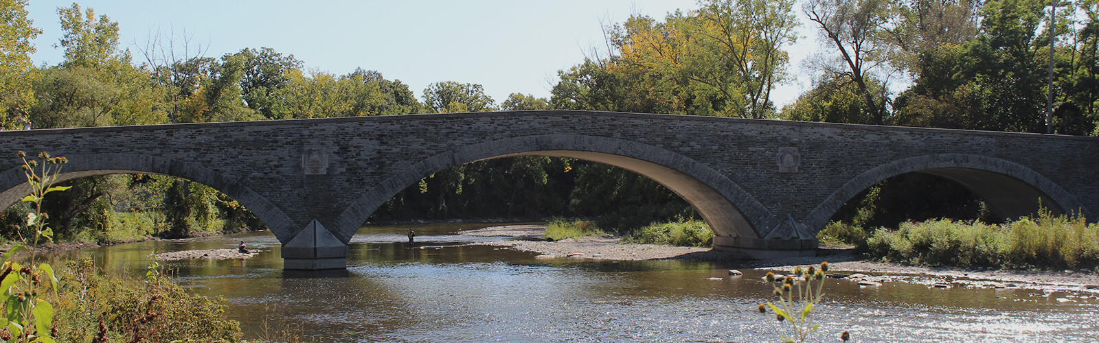
Lambton Mills Bridge Abutments
Along Humber River Recreational Trail
The first Dundas Street crossing of the Humber River was located at Lambton Mills, at which there were a series of bridges between in 1811 and 1955. The existing abutments were built around 1880 and supported a number of these bridges. The last bridge was built in 1907 and removed in 1955. It was a truss bridge engineered by the notable Frank Barber, consulting engineer and Vaughan Township Engineer. This site is part of The Shared Path/Le Sentier Partag: Toronto Historical Park, launched in spring 2011, which runs along the Humber Recreation Trail from Dundas Street to Lake Ontario.
Anna Camilleri and Tristan R. Whiston 'Album' Mural
Under Dundas Street Bridge Along Humber River Recreational Trail
In 2015, artists Anna Camilleri and Tristan R. Whiston painted this mural on the pillars of the Dundas Street West Bridge as part of the Pan Am Path to honour the contributions of lesbian, gay, bisexual, transgender and queer (LGBTQ2S+) individuals in sports while simultaneously confronting traditional representations of athletes and of family. The artists were inspired by Article 16 of the Universal Declaration of Human Rights, which recognizes the human right for people of all genders to form families. The mural depicts abstracted figures that represent families, with various faces and designs in mosaic form. Community members contributed to the creation of the mosaic pieces through workshops.
Dundas Street Bridge
Dundas Street West Crossing the Humber River (viewable from Humber River Recreational Trail)
This bridge connects York with Etobicoke. When it was first built, Dundas Street followed a different route, with a lower crossing on the Humber River located further south. In 1929, Dundas Street West was rerouted and straightened and the current Dundas Street Bridge was built. In 2009, the bridge was refurbished to maintain the heritage design. Plaques commemorating the Humber River as a Canadian Heritage River were affixed to the bridge railings and a viewing platform was installed.
The Shared Path
Along Humber River Recreational Trail
The Shared Path is part of the Humber River Recreational Trail, which follows along the Humber River between Lake Ontario and the Dundas Street Bridge. The trail was established on a 50-kilometre-long footpath known as the Toronto Carrying Place Trail, which runs along the Humber River to Lake Simcoe and was established by First Nations Peoples thousands of years ago. Today, the Shared Path is Toronto's first historical park and consists of 13 Story Circles, which are circular sections of the path with historical plaques, along both sides of the Humber below Dundas Street. The plaques describing each site are written in English, French and Ojibwe.
Lambton Canadian Pacific Railway Bridge
Crosses the Humber River, north of Dundas Street West (viewable from Humber River Recreational Trail)
Crossing the Humber River north of Lambton Park is the 171-metre bridge originally constructed for the Credit Valley Railway (CVR). The bridge was completed in 1874 with one track that led to Lambton Station (no longer in existence). Today the line is operated by the Canadian Pacific Railway (CPR) and the bridge provides access to Lambton Yards, a storage and maintenance facility built in 1912 located in the Junction neighbourhood. Lambton Yards is still in use today, accommodating trains carrying freight within parts of Southwestern Ontario. The railway was essential for the development of milling industries along the Humber River, including Lambton Mills. The CVR also delivered reddish-brown sandstone quarried at Forks of the Credit, used to build some of Toronto's important structures, including the Ontario Legislative Building and Old City Hall. The bridge was extended in 1914 using concrete, but the original 1874 stonework can be still seen.
Explore Lambton Baby Point
Now is the time for residents to experience all that tourists have been raving about for years. Discover shops, stops, places and spaces on city main streets. Stay curious, Toronto.
We want to hear from you! Click here to complete a short survey
We hope that you enjoyed exploring this Toronto neighbourhood and found many other points of interest along the way. While StrollTO highlights some of the 'hidden gems' in the neighbourhood, there may be others that could be included in a future edition. Would you like to share a point of interest that you discovered in the neighbourhood? Email us at [email protected].
Neighbourhood Stroll
This historic neighbourhood features an exciting mix of both urban and natural amenities. Remnants of some of the earliest Indigenous settlements in Toronto have been uncovered here, and it was also among the first areas settled by Europeans thereafter. Beautiful, historic homes can be found throughout much of the area, some of which were owned by some of Toronto's most famous citizens. The Humber River snakes through the area, offering a fantastic trail along it with several fascinating points of interest along the way. Fantastic local businesses can be found along Bloor Street West, Jane Street, and Annette Street in both the Bloor West Village and Baby Point Gates BIAs.
- Former Conn Smythe House
68 Baby Point Road
*Note: Private Property. Please observe the house from the sidewalk only. This heritage-designated house was once home to legendary Toronto Maple Leafs founder Conn Smythe. Smythe commissioned the house in 1926, to be designed in Arts and Crafts/Tudor Revival style by George Roper Gouinlock - the son of famous Toronto architect G.W. Gouinlock. Smythe moved into the home in 1927, and continued to live there until his death in 1980.
- Baby Point Gates & Former Home Smith House
Intersection of Jane Street and Baby Point Road & 400 Jane Street
*Note: 400 Jane Street is private property. Please observe the house from the sidewalk only. These gates were constructed in 1911 by Robert Home Smith, the man responsible for developing much of the area nearby into a residential enclave. Home Smith was a proponent of the Garden Suburb approach to neighbourhood development, defined by picturesque streets that followed natural landscape features, homes designed in English Revival styles, landscaped yards and access to parks, a valuation of private space and design restrictions to preserve the natural and built character of the neighbourhood. Home Smith also constructed what is now a heritage-designated home for himself at 400 Jane Street, which is located right behind the gates. In 2011, a BIA was formed by many of the local businesses in the area, and they chose to name themselves the Baby Point Gates BIA after the gates. A small plaque in the parkette beside the gates commemorates this history.
- Walter Ruston Murals
268 Jane Street
This mural was commissioned by the Baby Point Gates BIA and painted by local artist Walter Ruston in 2011. It depicts an historic scenes along the Humber River, showing Indigenous peoples traversing the river in canoes. Ruston consulted with local neighbourhood resident and historian Madeleine McDowell, who provided a large amount of historical records and photographs that helped inspire his work.
- Great White Oak Tree
37 Weatherell Street
*Note: Partial Private Property. Please observe the tree from the sidewalk only. The Great White Oak Tree can be spotted here, albeit the tree is located today on private property. Aside from spiritual significances, trees were widely used by most Indigenous nations to build everything from lodges to canoes. Mind you Indigenous nations are as diverse as the ecologies of Turtle Island. Where a lodge might've been built from oak in one ecology, people in other areas would have used another kind of tree. Each nation was influenced by its specific ecological context. The tree you see here is a designated member of the Tuhbenahneequay Ancient Grove which acknowledges trees along the historic Toronto Carrying Place that are over a century old. The name Tuhbenahneequay was chosen as a tribute to the daughter of Wabanosay, Chief of the Mississaugas of the New Credit First Nation at the time of the Toronto Purchase. This particular tree is estimated to be over 300 years old, and is likely among the oldest surviving trees in Toronto.
- Etienne Brule Park
13 Crosby Avenue
Etienne Brule Park is a historically significant piece of land. It was named after Etienne Brule, the first French explorer to venture beyond the St. Lawrence River into Upper Canada (Ontario). The Humber River and its shores along Etienne Brule Park were once used as a major trade route by the Indigenous Peoples of the area. It is a beautiful park stretched out along the Humber River starting near the Old Mill and winding north to the bend in the River around the Baby Point neighbourhood. Within this park you will find interpretive signage with information about the history of the area and its traditional uses. You will also find a ball diamond, a great hiking trail and lovely spots for a small picnic along the way. Etienne Brule Park is the centre point between the Humber River, Old Mill & Marshes, and the Lambton House Hotel & Lower Humber River Discovery Walks.
- Magwood Sanctuary
Along Humber Recreational Trail
This park is home to deciduous forest and wetland habitats. Community groups have conducted walking tours and plantings of the area to educate the community on the environmental and cultural heritage of Magwood and to combat invasive plant species. The park is located on the traditional territory of many First Nations peoples, and is a sacred place. The Thunderbird Burial Mound is located within the park and is estimated to be six thousand years old. The park is also significant due to its relationship with the village of Teiaiagon. This burial mound is under threat from erosion and from pedestrian traffic in the area. The Taiaiako'n Historical Preservation Society is actively protecting the site.
- Lambton House
4066 Old Dundas Street
Lambton House was a stagecoach inn and tavern, formerly known as Lambton Tavern and the Lambton Hotel, and is the last remaining pre-Confederation public building in situ on the lower Humber River. Lambton House and the surrounding area were located in Cooper's Mills. The mill had a blacksmith, tavern, post office and other businesses that soon formed a flourishing village. In 1840, Sir William Pearce Howland, a prominent businessman and politician, purchased Cooper's Mills and renamed it Lambton Mills in honour of John George Lambton, who came to the colony for 4 months, and wrote the Durham Report recommending Responsible Government, the basis for our form of Government. Lambton House was most likely built by William Tyrell, who was a local architect and contractor, and the first Reeve of the Town of Weston. A building opened on this site in 1848 and the current building in 1860, and the licensed business operated for 140 years before closing its doors as a tavern in 1989. In 1985, it was designated as a heritage property. Today, Lambton House is a community hub, hosting events and activities, including exhibits such as the Specimen Wildflower Garden on the front east yard, lectures, talks, pub nights, concerts, Canada Day celebrations, and Lower Humber Interpretative Centre
- Lambton Mills Bridge Abutments
Along Humber River Recreational Trail
The first Dundas Street crossing of the Humber River was located at Lambton Mills, at which there were a series of bridges between in 1811 and 1955. The existing abutments were built around 1880 and supported a number of these bridges. The last bridge was built in 1907 and removed in 1955. It was a truss bridge engineered by the notable Frank Barber, consulting engineer and Vaughan Township Engineer. This site is part of The Shared Path/Le Sentier Partag: Toronto Historical Park, launched in spring 2011, which runs along the Humber Recreation Trail from Dundas Street to Lake Ontario.
- Anna Camilleri and Tristan R. Whiston 'Album' Mural
Under Dundas Street Bridge Along Humber River Recreational Trail
In 2015, artists Anna Camilleri and Tristan R. Whiston painted this mural on the pillars of the Dundas Street West Bridge as part of the Pan Am Path to honour the contributions of lesbian, gay, bisexual, transgender and queer (LGBTQ2S+) individuals in sports while simultaneously confronting traditional representations of athletes and of family. The artists were inspired by Article 16 of the Universal Declaration of Human Rights, which recognizes the human right for people of all genders to form families. The mural depicts abstracted figures that represent families, with various faces and designs in mosaic form. Community members contributed to the creation of the mosaic pieces through workshops.
- Dundas Street Bridge
Dundas Street West Crossing the Humber River (viewable from Humber River Recreational Trail)
This bridge connects York with Etobicoke. When it was first built, Dundas Street followed a different route, with a lower crossing on the Humber River located further south. In 1929, Dundas Street West was rerouted and straightened and the current Dundas Street Bridge was built. In 2009, the bridge was refurbished to maintain the heritage design. Plaques commemorating the Humber River as a Canadian Heritage River were affixed to the bridge railings and a viewing platform was installed.
- The Shared Path
Along Humber River Recreational Trail
The Shared Path is part of the Humber River Recreational Trail, which follows along the Humber River between Lake Ontario and the Dundas Street Bridge. The trail was established on a 50-kilometre-long footpath known as the Toronto Carrying Place Trail, which runs along the Humber River to Lake Simcoe and was established by First Nations Peoples thousands of years ago. Today, the Shared Path is Toronto's first historical park and consists of 13 Story Circles, which are circular sections of the path with historical plaques, along both sides of the Humber below Dundas Street. The plaques describing each site are written in English, French and Ojibwe.
- Lambton Canadian Pacific Railway Bridge
Crosses the Humber River, north of Dundas Street West (viewable from Humber River Recreational Trail)
Crossing the Humber River north of Lambton Park is the 171-metre bridge originally constructed for the Credit Valley Railway (CVR). The bridge was completed in 1874 with one track that led to Lambton Station (no longer in existence). Today the line is operated by the Canadian Pacific Railway (CPR) and the bridge provides access to Lambton Yards, a storage and maintenance facility built in 1912 located in the Junction neighbourhood. Lambton Yards is still in use today, accommodating trains carrying freight within parts of Southwestern Ontario. The railway was essential for the development of milling industries along the Humber River, including Lambton Mills. The CVR also delivered reddish-brown sandstone quarried at Forks of the Credit, used to build some of Toronto's important structures, including the Ontario Legislative Building and Old City Hall. The bridge was extended in 1914 using concrete, but the original 1874 stonework can be still seen.
Accessibility information: Most points of interest on this stroll are viewable from the street or from a paved park path. The Lambton Mills Bridge Abutments are located on a dirt path. While there is a fully paved path leading through most of the Magwood Sanctuary, other portions of the park contain dirt paths.
The StrollTO itineraries may follow routes that do not receive winter maintenance. Please review winter safety tips and for more information contact 311.
Soundtracks of the City
From global superstars to local favourites and ones to watch, the Soundtracks of the City playlists all feature artists who have called Toronto home. Whether it’s a lyric about the neighborhood, an artist representing a cultural community, or a tie-in to the StrollTO itinerary itself, all the music reflects connections to an individual ward or the City as a whole.
Music was chosen based on an artist’s Spotify presence and each song’s broad appeal, as well as its associations with the cultures, languages and ethnicities that reflect Toronto’s neighborhoods and diverse music scene. Soundtracks of the City combines 425 songs that feature more than 500 different local artists or acts, showcasing songs in 23 different languages.