

West Rouge
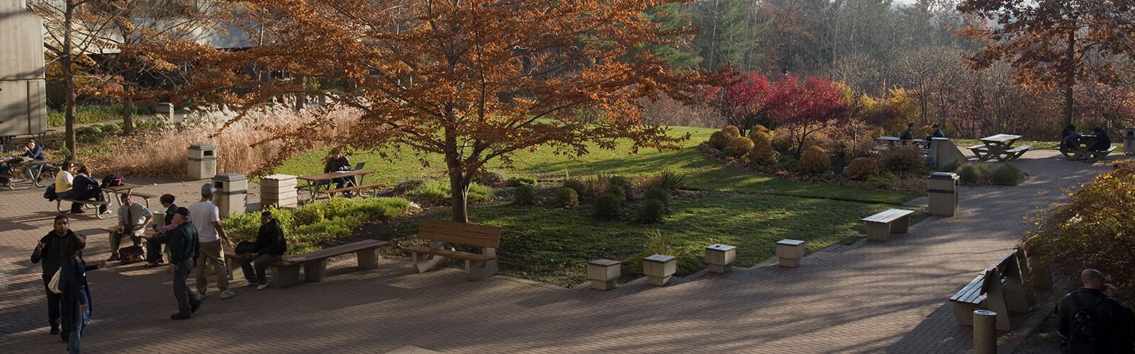
Gatineau Hydro Corridor Trail
West-East Path Accessible Between Conlins Road and Dean Park Road
The City of Toronto, community environmental groups and local residents have teamed up to build a continuous trail and to plant native trees and wildflowers. The trail is part of a project, called the Meadoway, which is a partnership involving the City of Toronto, Toronto and Region Conservation Authority and the W. Garfield Weston Foundation. It will connect four ravines, 15 parks and over 30 neighbourhoods in Scarborough, enabling cyclists and pedestrians to travel through the park from the Don River East to Rouge National Urban Park. The area will soon be able to support a greater diversity of local wildlife and plant life as well as create recreational greenspace for local community members along the path.
Dean Park Walkway
65 Dean Park Road
Dean Park Walkway is a short treed greenbelt running from Dean Park near Meadowvale Road and Highway 401 up towards Sheppard Avenue. The park is a lovely neighbourhood park with a soccer field, baseball diamond and playground. It is also an excellent way to travel through the neighbourhood without the hustle and bustle of traffic.
Chief Dan George Public School
185 Generation Boulevard
This public school is named after Chief Dan George, an Indigenous author, film actor and chief. Born Geswanouth Slahoot in 1899 on the Burrard Inlet Reserve outside of Vancouver, he was forced to change his name when he entered residential school. He was the Chief of the Tsleil-Waututh First Nation from 1951 to 1963. He became a successful film actor in his 70s, starring in famous films such as 'Little Big Man' with Dustin Hoffman - for which he was nominated for an Academy Award for Best Supporting Actor - as well as 'The Outlaw Josey Wales' with Clint Eastwood. He was outspoken on Indigenous issues throughout his life, promoting environmental causes, spiritual healing, and traditional values. He was made an Officer of the Order of Canada in 1971, and was featured on a Canada Post stamp in 2008 as part of the 'Canadians in Hollywood' series.
Glen Rouge Campground and Mast Trail
7450 Kingston Road
*Please note: campground is currently under renovation, but Mast Trail is still accessible. The last remaining campground in Toronto, Glen Rouge occupies a site that has operated as a campground since 1923. Originally called Graham Park after its founder Jack Graham, the site featured 10 campsites with plenty of leisure activities, a small dance pavilion, and a restaurant, The property was purchased by the Toronto Region and Conservation Authority (TRCA) after Hurricane Hazel destroyed the campground in October 1954, which continues to operate it to this day. Also accessible from the campground's parking lot is the south trailhead of the spectacular Mast Trail, which wends its way through parts of Rouge National Urban Park. The trail features excellent examples of Carolinian ecosystems along a former logging route.
Fanfare Park
40 Fanfare Avenue
A 1.3 hectare park near Port Union Road and Highway 401 featuring a children's playground and a dry creek bed along the west side of the park that is filled with mature trees. This park features plenty of naturalized space and a toboggan hill.
Port Union Village Common Park
150 Bridgend Street
A 4.2 hectare park near Port Union Road and Lawrence Avenue East is a linear park bounded by the CN railway to the south that features a children's playground and paths accessing the surrounding neighbourhoods and the Lake Ontario waterfront.
Great Lakes Waterfront Trail
Runs Along Lake Ontario Between Port Union Waterfront Park and Rouge Beach Park
This section of the Great Lakes Waterfront Trail offers spectacular views over Lake Ontario and its shoreline. The 4km section of the trail was completed in two stages in 2006 and 2012 and offers recreational space along a part of Toronto's eastern waterfront that was not previously publicly accessible. Some notable features along the trail include a pedestrian tunnel featuring public art by a local artist, 10 cobblestone beaches, and a connection at its eastern end to the City of Pickering over the Rouge River. This section is part of the Great Lakes Waterfront Trail, a 3600km signed route connecting 155 communities and First Nations along the shorelines of the Great Lakes region.
Port Union Waterfront Park
175 Chesterton Shores
Located at the eastern edge of the city between the mouth of Highland Creek and the Rouge River, this waterfront park provides 13.5 hectares of green space and connects the Port Union community to Lake Ontario. It features 3.8 kilometers of continuous waterfront trail, great views of Lake Ontario and its shoreline, a new pedestrian bridge over Highland Creek and trail connections north into the Highland Creek watershed. At the city's edge, the existing bridge over the Rouge River connects the park to the City of Pickering.
Rouge Beach Park
195 Rouge Hills Drive
Part of the larger Rouge National Urban Park, Rouge Beach Park is located at the mouth of the Rouge River and is one of Toronto's swimming beaches. The Rouge River and its main tributary Little Rouge Creek flow through an area that remains largely undeveloped. Early eighteenth-century explorers named the river for the red colour of the water. Red clay in the river's banks give the water a distinct red colour as it flows towards Lake Ontario.
West Rouge Community Centre
270 Rouge Hills Drive
West Rouge Community Centre has a long history in East Scarborough. The building was the clubhouse for a former golf course. Now being apart of the City of Toronto, the Community Centre is prime site for rental use of the Ballroom which is used for wedding receptions, preteen dances, special events and for recreation programming. West Rouge Community Centre has many preschool programs that run out of the Tots Room that gets many compliments from visitors throughout the year. Also, many community groups call the community centre home, such as West Rouge Sport and Recreation Association, West Rouge Community Association and the Dukes of Harmony to name a few.
Explore West Rouge
Now is the time for residents to experience all that tourists have been raving about for years. Discover shops, stops, places and spaces on city main streets. Stay curious, Toronto.
We want to hear from you! Click here to complete a short survey
We hope that you enjoyed exploring this Toronto neighbourhood and found many other points of interest along the way. While StrollTO highlights some of the 'hidden gems' in the neighbourhood, there may be others that could be included in a future edition. Would you like to share a point of interest that you discovered in the neighbourhood? Email us at [email protected].
Neighbourhood Stroll
This largely residential area on the shores of Lake Ontario is Toronto's easternmost neighbourhood. Some of the finest waterfront and parkland in the city can be found here, with the Great Lakes Waterfront Trail running along the shore and a portion of the spectacular Rouge National Urban Park. Great local businesses can be found along Sheppard Avenue East and Port Union Road.
- Gatineau Hydro Corridor Trail
West-East Path Accessible Between Conlins Road and Dean Park Road
The City of Toronto, community environmental groups and local residents have teamed up to build a continuous trail and to plant native trees and wildflowers. The trail is part of a project, called the Meadoway, which is a partnership involving the City of Toronto, Toronto and Region Conservation Authority and the W. Garfield Weston Foundation. It will connect four ravines, 15 parks and over 30 neighbourhoods in Scarborough, enabling cyclists and pedestrians to travel through the park from the Don River East to Rouge National Urban Park. The area will soon be able to support a greater diversity of local wildlife and plant life as well as create recreational greenspace for local community members along the path.
- Dean Park Walkway
65 Dean Park Road
Dean Park Walkway is a short treed greenbelt running from Dean Park near Meadowvale Road and Highway 401 up towards Sheppard Avenue. The park is a lovely neighbourhood park with a soccer field, baseball diamond and playground. It is also an excellent way to travel through the neighbourhood without the hustle and bustle of traffic.
- Chief Dan George Public School
185 Generation Boulevard
This public school is named after Chief Dan George, an Indigenous author, film actor and chief. Born Geswanouth Slahoot in 1899 on the Burrard Inlet Reserve outside of Vancouver, he was forced to change his name when he entered residential school. He was the Chief of the Tsleil-Waututh First Nation from 1951 to 1963. He became a successful film actor in his 70s, starring in famous films such as 'Little Big Man' with Dustin Hoffman - for which he was nominated for an Academy Award for Best Supporting Actor - as well as 'The Outlaw Josey Wales' with Clint Eastwood. He was outspoken on Indigenous issues throughout his life, promoting environmental causes, spiritual healing, and traditional values. He was made an Officer of the Order of Canada in 1971, and was featured on a Canada Post stamp in 2008 as part of the 'Canadians in Hollywood' series.
- Glen Rouge Campground and Mast Trail
7450 Kingston Road
*Please note: campground is currently under renovation, but Mast Trail is still accessible. The last remaining campground in Toronto, Glen Rouge occupies a site that has operated as a campground since 1923. Originally called Graham Park after its founder Jack Graham, the site featured 10 campsites with plenty of leisure activities, a small dance pavilion, and a restaurant, The property was purchased by the Toronto Region and Conservation Authority (TRCA) after Hurricane Hazel destroyed the campground in October 1954, which continues to operate it to this day. Also accessible from the campground's parking lot is the south trailhead of the spectacular Mast Trail, which wends its way through parts of Rouge National Urban Park. The trail features excellent examples of Carolinian ecosystems along a former logging route.
- Fanfare Park
40 Fanfare Avenue
A 1.3 hectare park near Port Union Road and Highway 401 featuring a children's playground and a dry creek bed along the west side of the park that is filled with mature trees. This park features plenty of naturalized space and a toboggan hill.
- Port Union Village Common Park
150 Bridgend Street
A 4.2 hectare park near Port Union Road and Lawrence Avenue East is a linear park bounded by the CN railway to the south that features a children's playground and paths accessing the surrounding neighbourhoods and the Lake Ontario waterfront.
- Great Lakes Waterfront Trail
Runs Along Lake Ontario Between Port Union Waterfront Park and Rouge Beach Park
This section of the Great Lakes Waterfront Trail offers spectacular views over Lake Ontario and its shoreline. The 4km section of the trail was completed in two stages in 2006 and 2012 and offers recreational space along a part of Toronto's eastern waterfront that was not previously publicly accessible. Some notable features along the trail include a pedestrian tunnel featuring public art by a local artist, 10 cobblestone beaches, and a connection at its eastern end to the City of Pickering over the Rouge River. This section is part of the Great Lakes Waterfront Trail, a 3600km signed route connecting 155 communities and First Nations along the shorelines of the Great Lakes region.
- Port Union Waterfront Park
175 Chesterton Shores
Located at the eastern edge of the city between the mouth of Highland Creek and the Rouge River, this waterfront park provides 13.5 hectares of green space and connects the Port Union community to Lake Ontario. It features 3.8 kilometers of continuous waterfront trail, great views of Lake Ontario and its shoreline, a new pedestrian bridge over Highland Creek and trail connections north into the Highland Creek watershed. At the city's edge, the existing bridge over the Rouge River connects the park to the City of Pickering.
- Rouge Beach Park
195 Rouge Hills Drive
Part of the larger Rouge National Urban Park, Rouge Beach Park is located at the mouth of the Rouge River and is one of Toronto's swimming beaches. The Rouge River and its main tributary Little Rouge Creek flow through an area that remains largely undeveloped. Early eighteenth-century explorers named the river for the red colour of the water. Red clay in the river's banks give the water a distinct red colour as it flows towards Lake Ontario.
- West Rouge Community Centre
270 Rouge Hills Drive
West Rouge Community Centre has a long history in East Scarborough. The building was the clubhouse for a former golf course. Now being apart of the City of Toronto, the Community Centre is prime site for rental use of the Ballroom which is used for wedding receptions, preteen dances, special events and for recreation programming. West Rouge Community Centre has many preschool programs that run out of the Tots Room that gets many compliments from visitors throughout the year. Also, many community groups call the community centre home, such as West Rouge Sport and Recreation Association, West Rouge Community Association and the Dukes of Harmony to name a few.
Accessibility information: Most points of interest are visible from the street, paved park trail, or boardwalk though there are sections that may include unpaved paths and drastic elevation changes - particularly the Mast Trail. Please exercise caution when crossing over Highway 401 along Port Union Road as there is one instance where a highway onramp with high speed traffic will need to be traversed.
The StrollTO itineraries may follow routes that do not receive winter maintenance. Please review winter safety tips and for more information contact 311.
Soundtracks of the City
From global superstars to local favourites and ones to watch, the Soundtracks of the City playlists all feature artists who have called Toronto home. Whether it’s a lyric about the neighborhood, an artist representing a cultural community, or a tie-in to the StrollTO itinerary itself, all the music reflects connections to an individual ward or the City as a whole.
Music was chosen based on an artist’s Spotify presence and each song’s broad appeal, as well as its associations with the cultures, languages and ethnicities that reflect Toronto’s neighborhoods and diverse music scene. Soundtracks of the City combines 425 songs that feature more than 500 different local artists or acts, showcasing songs in 23 different languages.