

Woodbine Corridor
Charles Coxwell Small Land
470 Woodbine Avenue
In the early to mid-nineteenth century, a man named Charles Coxwell Small, a wealthy farmer and public official of Upper Canada, bought a 472-acre plot of land. The area stretched from present day Woodbine Avenue to Coxwell Avenue and Lake Ontario up to Danforth Avenue. He built a road along the west side of his land (now Coxwell Avenue). In 1853, Charles donated three acres of his estate to the local Anglican church, so they could move their meetings out of the local pub and into their own church building. A school house was the first building on site, and was moved here by a team of oxen. The school's bell is all that's left, now hung in the cemetery's crematorium. St. John the Baptist Norway Anglican Church was completed shortly after, but was replaced in 1893 thanks to its growing congregation. The cemetery was originally Anglican-only but has since become interfaith, with eighty thousand graves. One of the most notable families buried here is that of Kew Gardens' founder, Joseph Williams.
Small's Pond at Orchard Park
1987 Dundas Street East
Small's Pond was a large pond on Charles Coxwell Small's property. It was a natural U-shaped pond, centred on Queen Street East and Kingston Road, and stretched into two branches roughly forty feet wide, that ran parallel to Coxwell Avenue and Kingston Road. It was a popular boating spot for locals in the summers and skating in the winters. When the pond froze, workers would chip at the ice and sell it (ice from the polluted Don River was no longer an option). Unfortunately, due to pollution of the ponds' two main tributaries, it was drained in 1935 to make room for further development (including this park). Orchard Park features a firepit, outdoor table tennis, a playground and a splash pad.
Fairmount Park
1725 Gerrard Street East
A 1.9-hectare park featuring two ball diamonds, a multipurpose sports field, five outdoor tennis courts, a wading pool, a children's playground and a natural ice rink in the winter. At the east side of the park is the Fairmount Park Community Centre and its indoor swimming pool. The park also includes some special features like a bake oven, firepit and outdoor table tennis.
Williamson Park Ravine
1680 Gerrard Street East
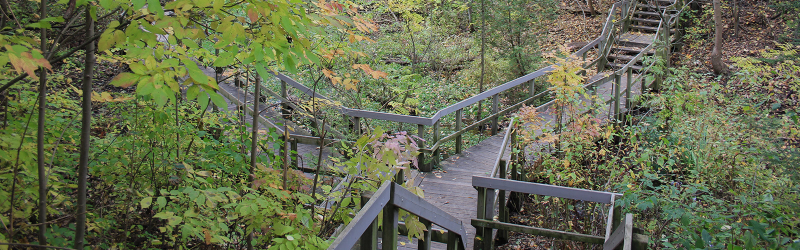
Williamson Park Ravine is named in memory of William Williamson (1857 - 1949) who was a manufacturer, builder, alderman and Justice of the Peace and contributed much to the early life of Toronto. The land in which the park runs through, was donated by Williams' family. The ravine is a 500-metre long stretch of deciduous forest on steep-banked ravine slopes. It has been designated as an Environmentally Significant Area (ESA) in the City of Toronto Official Plan because it provides habitats for vulnerable, rare or threatened plant and/or animal species and communities.
Eric Kristmanson (Poser) & Jieun Kim Mural
1917 Gerrard Street East
This mural collaboration is a colourful mashup of both artists' styles. It incorporates a mural that existed on this wall previously: a beach scene with a palm tree. The design also references an historical 19-hole golf course that was once the landscape of this area.
MEDIAH (Evond Blake) 'THE RADI'AAL ENCOMPASS' Mural
Woodbine Avenue underpass between Darrell Avenue and Aldergrove Avenue
This mural, 'THE RADI'AAL ENCOMPASS', depicts dynamic movement and togetherness and represents the entrance way into the surrounding communities.
Merrill Bridge Road Park and Small's Creek
1 East Lynn Avenue
Small's Creek is named after Charles Coxwell Small who owned this land in the mid-1800s. The creek is one of two main tributaries that fed into Small's Pond before it was drained. The creek runs through four ravine parks including Merrill Bridge Road Park. The 1.4-hectare park features an off leash dogs area and the west end of the park leads down into a forested ravine where you can follow Small's Creek for part of the way.
East Lynn Park
1949 Danforth Avenue
East Lynn Park is the heart of the Woodbine and Danforth neighbourhood. The park is animated by active community organizations like the Danforth East Community Association (DECA) and The Danforth Mosaic BIA, which runs festivals, events, farmers' markets and arts markets in the park all year long. With a playground, splash pad and toboggan hills, the park is always a popular spot for local families.
Danforth Carhouse and Garage
1627 Danforth Avenue
*Note: Private property. Please observe the building from the street only. Built in 1915, this streetcar storage facility was key to the expansion of Toronto Civic Railway's streetcar network in the east end and operated as a public transit vehicle barn for 87 years. After the streetcar system was taken over by the Toronto Transit Commission (TTC) in 1921, the carhouse was expanded until it was able to store and service 54 streetcars on 17 tracks in the yard, handling streetcars for major routes. In 1967, after the closing of many of these streetcar routes, the TTC set to work converting the facility to an all-bus garage. The refurbished sixty-thousand square foot complex could handle 134 buses at its peak. No longer used to serve vehicles, the building is still owned by the TTC and is used for offices and equipment storage.
Sean Martindale Mural
695 Coxwell Avenue
The theme for this mural is 'transitions' and was inspired by the TTC transit site and the neighbourhood's evolution and growth. The artist developed the concept after ten days of community interaction during the Art of the Danforth Festival in May 2014.
Explore Woodbine Corridor
Now is the time for residents to experience all that tourists have been raving about for years. Discover shops, stops, places and spaces on city main streets. Stay curious, Toronto.
We want to hear from you! Click here to complete a short survey
We hope that you enjoyed exploring this Toronto neighbourhood and found many other points of interest along the way. While StrollTO highlights some of the 'hidden gems' in the neighbourhood, there may be others that could be included in a future edition. Would you like to share a point of interest that you discovered in the neighbourhood? Email us at [email protected].
Neighbourhood Stroll
The Woodbine Corridor neighbourhood is packed with beautiful historic homes, and lush green parks and ravines. The Danforth Mosaic BIA, Gerrard India Bazaar and The Beach BIAs offer a wide variety of local businesses and restaurants.
- Charles Coxwell Small Land
470 Woodbine Avenue
In the early to mid-nineteenth century, a man named Charles Coxwell Small, a wealthy farmer and public official of Upper Canada, bought a 472-acre plot of land. The area stretched from present day Woodbine Avenue to Coxwell Avenue and Lake Ontario up to Danforth Avenue. He built a road along the west side of his land (now Coxwell Avenue). In 1853, Charles donated three acres of his estate to the local Anglican church, so they could move their meetings out of the local pub and into their own church building. A school house was the first building on site, and was moved here by a team of oxen. The school's bell is all that's left, now hung in the cemetery's crematorium. St. John the Baptist Norway Anglican Church was completed shortly after, but was replaced in 1893 thanks to its growing congregation. The cemetery was originally Anglican-only but has since become interfaith, with eighty thousand graves. One of the most notable families buried here is that of Kew Gardens' founder, Joseph Williams.
- Small's Pond at Orchard Park
1987 Dundas Street East
Small's Pond was a large pond on Charles Coxwell Small's property. It was a natural U-shaped pond, centred on Queen Street East and Kingston Road, and stretched into two branches roughly forty feet wide, that ran parallel to Coxwell Avenue and Kingston Road. It was a popular boating spot for locals in the summers and skating in the winters. When the pond froze, workers would chip at the ice and sell it (ice from the polluted Don River was no longer an option). Unfortunately, due to pollution of the ponds' two main tributaries, it was drained in 1935 to make room for further development (including this park). Orchard Park features a firepit, outdoor table tennis, a playground and a splash pad.
- Fairmount Park
1725 Gerrard Street East
A 1.9-hectare park featuring two ball diamonds, a multipurpose sports field, five outdoor tennis courts, a wading pool, a children's playground and a natural ice rink in the winter. At the east side of the park is the Fairmount Park Community Centre and its indoor swimming pool. The park also includes some special features like a bake oven, firepit and outdoor table tennis.
- Williamson Park Ravine
1680 Gerrard Street East
Williamson Park Ravine is named in memory of William Williamson (1857 - 1949) who was a manufacturer, builder, alderman and Justice of the Peace and contributed much to the early life of Toronto. The land in which the park runs through, was donated by Williams' family. The ravine is a 500-metre long stretch of deciduous forest on steep-banked ravine slopes. It has been designated as an Environmentally Significant Area (ESA) in the City of Toronto Official Plan because it provides habitats for vulnerable, rare or threatened plant and/or animal species and communities.
- Eric Kristmanson (Poser) & Jieun Kim Mural
1917 Gerrard Street East
This mural collaboration is a colourful mashup of both artists' styles. It incorporates a mural that existed on this wall previously: a beach scene with a palm tree. The design also references an historical 19-hole golf course that was once the landscape of this area.
- MEDIAH (Evond Blake) 'THE RADI'AAL ENCOMPASS' Mural
Woodbine Avenue underpass between Darrell Avenue and Aldergrove Avenue
This mural, 'THE RADI'AAL ENCOMPASS', depicts dynamic movement and togetherness and represents the entrance way into the surrounding communities.
- Merrill Bridge Road Park and Small's Creek
1 East Lynn Avenue
Small's Creek is named after Charles Coxwell Small who owned this land in the mid-1800s. The creek is one of two main tributaries that fed into Small's Pond before it was drained. The creek runs through four ravine parks including Merrill Bridge Road Park. The 1.4-hectare park features an off leash dogs area and the west end of the park leads down into a forested ravine where you can follow Small's Creek for part of the way.
- East Lynn Park
1949 Danforth Avenue
East Lynn Park is the heart of the Woodbine and Danforth neighbourhood. The park is animated by active community organizations like the Danforth East Community Association (DECA) and The Danforth Mosaic BIA, which runs festivals, events, farmers' markets and arts markets in the park all year long. With a playground, splash pad and toboggan hills, the park is always a popular spot for local families.
- Danforth Carhouse and Garage
1627 Danforth Avenue
*Note: Private property. Please observe the building from the street only. Built in 1915, this streetcar storage facility was key to the expansion of Toronto Civic Railway's streetcar network in the east end and operated as a public transit vehicle barn for 87 years. After the streetcar system was taken over by the Toronto Transit Commission (TTC) in 1921, the carhouse was expanded until it was able to store and service 54 streetcars on 17 tracks in the yard, handling streetcars for major routes. In 1967, after the closing of many of these streetcar routes, the TTC set to work converting the facility to an all-bus garage. The refurbished sixty-thousand square foot complex could handle 134 buses at its peak. No longer used to serve vehicles, the building is still owned by the TTC and is used for offices and equipment storage.
- Sean Martindale Mural
695 Coxwell Avenue
The theme for this mural is 'transitions' and was inspired by the TTC transit site and the neighbourhood's evolution and growth. The artist developed the concept after ten days of community interaction during the Art of the Danforth Festival in May 2014.
Accessibility information: Williamson Park Ravine, Merrill Bridge Road Park and Small's Creek are visible from a paved sidewalk but entering the ravine requires descending a wooden staircase, and the trail in the ravine incorporates both wooden boardwalks and uneven, dirt forest floor. The trail is not regularly maintained. Small's Creek runs through the ravines but may only be visible on the trail. The remaining points of interest are all visible from paved sidewalks.
The StrollTO itineraries may follow routes that do not receive winter maintenance. Please review winter safety tips and for more information contact 311.
Soundtracks of the City
From global superstars to local favourites and ones to watch, the Soundtracks of the City playlists all feature artists who have called Toronto home. Whether it’s a lyric about the neighborhood, an artist representing a cultural community, or a tie-in to the StrollTO itinerary itself, all the music reflects connections to an individual ward or the City as a whole.
Music was chosen based on an artist’s Spotify presence and each song’s broad appeal, as well as its associations with the cultures, languages and ethnicities that reflect Toronto’s neighborhoods and diverse music scene. Soundtracks of the City combines 425 songs that feature more than 500 different local artists or acts, showcasing songs in 23 different languages.